Join the discussion

Write your take first — we'll ask for email only when you're ready to publish.

  • Hacker News
  • That is so cool. I don't know what I would do with this but I want one!
  • These kind of project are now so easy. A few prompts and you have something like this. I did it with quite a few similar like projects. You can buy super cheap esps with integrated lcds for less than 20 dollars.
  • yeah, I've been dying to do something with ESP32, but still waiting for that idea. Something with eInk displays :D
  • Cool project! Funny how similar projects can pop-up at the same time; here is a somewhat similar project for identifying close-by flights, but this is a mobile app: https://github.com/etnt/skyoverhead
  • As I live on a widely used flight path, I also made one a while ago using a cheap ESP32 ($12) XiaoZhi AI display .

    I made it multi-purpose by showing air traffic when a flight enters the selected airspace and when there's no new traffic, it defaults to showing my Claude usage and reset duration. It works with ESPHome and also has Home Assistant Voice Assistant as I wanted to experiment with fully local HA Assist.

  • Looks pretty cool, though kinda "cheating" by pulling from adsb.fi - though I think you'd need something a lot more powerful than an ESP32 to receive and decode ADS-B ;)
  • You could fit a pi zero and rtl in an enclosure not much larger than the one they’ve printed.
  • Actually possible to receive and decode ADS-B on ESP32, but MLAT is failing (tried hard but not found a trick yet).

    Biggest problem isn’t that it’s not powerful enough, but the USB port bandwidth don’t match most SDR.

    Using some clever tricks you can receive parts of the message on a slower USB and be able to decode ADS-B

  • I would actually expect the math to decode ads-b traffic is substantially less complex than, for example, a TLS connection.
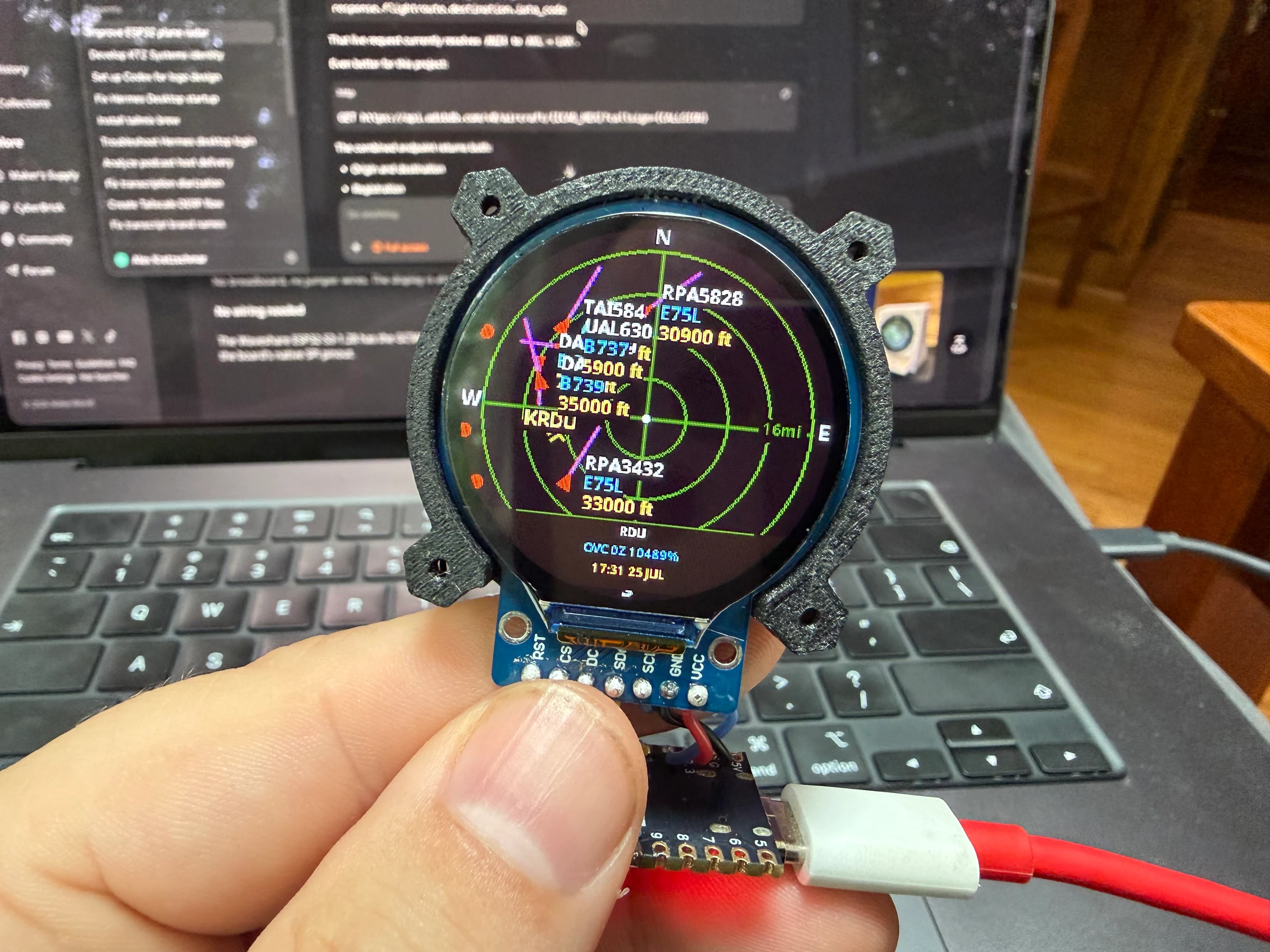
  • Using ADS-B and calling it a "radar" feels wrong to me.

    (But is is a cool project)

  • From https://news.ycombinator.com/item?id=43261684 :

    > Can any aircraft navigation system plot drone Remote ID beacons on a map?

    > How sensitive of a sensor array is necessary to trilaterate Remote ID signals and birds for aircraft collision avoidance?

    Could aircraft locate birds with CSI Channel State Information?

    > A Multispectral sensor array (standard) would probably be most robust.

    I started working on adding weather over HTTP (or from a LoRA message from a sender key on an allow-list) to an ESP32-S3 with a 2" eInk screen with Meshtastic InkHUD. I got to testing the output on the SPI display and wrote a codec to do 1bpp 1Hz video on ESP32 and then added gaussian splatting and layers to the codec (which is brand new), so now on paper it says it can do 3D scene rendering from a configurable perspective and rescaling of normed 3x3 tensors for the display size (2x2 tensors for 2D). Haven't tested that yet but I did ask it to add sensor fusion to try to track viewer positions(s) with an Accelerometer or Ultrasonic (which this device doesn't have) or Wi-Fi CSI Channel State information. I started working on the codec, MAV (Mu Animation Video), in ffmpeg and haven't yet implemented enough device simulator pitch/roll/yaw buttons to complete testing of the 3D on ESP32 with gaussian splatting yet.

    westurner/firmware: https://github.com/westurner/firmware/tree/add_weather_http_...

    There's probably already a flight sim game or screensaver that will render on esp32? It looks like there are a few games in the meshtastic firmware for TFT screens but not for InkHUD eInk at 1 Hz (1 fps)

  • ADS-B is not radar, despite ATC calling these sorts of things “secondary radar”.
  • Secondary radar historically was radar. ADS-B can be seen as kind of a replacement or complement, I guess that's why it falls under the same terminology.
  • Perhaps I didn’t read it thoroughly enough but it seems that lat/long of the “radar” are expected to be entered by user, I think using wifi positioning could be of great assist and could be done from mcu itself without involving web portal, though maybe portal already does it (didn’t get to see it)
  • Could use https://ipgeolocation.io to provide it however still requires configuring an API key like if the little airplane “radar” had a backend it could reach. For WiFi configuration, could use something like comitup [1]. Put together that would eliminate the need to login to the device.

    1. http://davesteele.github.io/comitup/

  • radar *display*

    making esp32-based radar emitter would've been cool, tho

  • Agree, and the display is called a PPI (https://en.wikipedia.org/wiki/Plan_position_indicator). Before computers, they were easy to connect to a scanning (rotating) radar since the "memory" was the phosphor in the display.
  • I live a couple of miles from an airport that houses a fire-fighting air tanker base, and I am somewhat terrified of fires- 120K Acres has burned in my area of the state so far this year.

    I've also been a ham radio enjoyer and had been looking for projects that work with radio. So I built a little antenna that works with ~1Mhz and hooked it to a raspberryPi running dump1090... it's amazing how far I can receive. 50-ish miles across a bunch of 12k-14k mountains.

    However, I've switched to just using one of the ADSB sites because they have a lot more tracking info.

    It's been super interesting to watch the tankers take off. Mostly c130 and md80, but there have been a pair of canadair float planes... quite a menagerie of aircraft.

    Anyhow, the adsb stuff gets really interesting once you identify the spotting planes, as it's a little faster at identifying where agencies are looking at fires than WatchDuty (which also works very well).

  • Can I privately reach out to you?
  • Well, a radar-like display, then. But not a radar.
  • Yeah, while this is a neat project, I was expecting something completely different (and possibly illegal I guess, I don't know).
  • I clicked through so fast thinking someone had made something that wasn’t simply pulling open source ADSB data and putting it onto a screen.
  • Exactly. Radar stands for "radio detection and ranging". Quoting https://en.wikipedia.org/wiki/Radar :

    > Radar is a system that uses radio waves to determine the distance (ranging), direction (azimuth and elevation angles), and radial velocity of objects relative to the site. It is a radiodetermination method used to detect and track aircraft [...]

    > A radar system consists of a transmitter producing electromagnetic waves in the radio or microwave domain, a transmitting antenna, a receiving antenna (often the same antenna is used for transmitting and receiving) and a receiver and processor to determine properties of the objects. Radio waves (pulsed or continuous) from the transmitter reflect off the objects and return to the receiver, giving information about the objects' locations and speeds.

    The OP's project only passively receives the digital location information of each airplane transmitted by the airplane itself. The project does not transmit radio waves nor do any physical determination of the plane's location.

    See also: https://en.wikipedia.org/wiki/Primary_radar (true radar), https://en.wikipedia.org/wiki/Primary_radar (ADS-B, which is what the OP receives)

  • Looks like several of these have come up in the past months, with the last one being a real product (that was on pre-order)

    - https://makerworld.com/models/2872376-esp32-plane-radar-live... (referenced by the linked article)

    - https://github.com/AnthonySturdy/micro-radar

    - https://www.gadgies.co.uk/shop/p/product-3-szb2y-gzh2r-tzhkx...

    Personally, I really like them. It's a nice gadget. :)