Join the discussion
Write your take first — we'll ask for email only when you're ready to publish.
- Hacker News
- Is it possible to avoid these risks in mountainous areas? How many people are living in valleys downstream from lakes with these risks?
If one simply concluded that with current climate changes, it's not safe for humans to live under that risk, how many villages and cities would find themselves uninhabitable all of a sudden?
by alkonaut - Not readily.
The events, even with increased frequency, are relatively rare (perhaps a few times a decade), quite sudden, utterly overwhelming, and destructive to virtually everything in their path.
The only assured safety practice would be to keep out of the danger zone entirely, and even this is challenging:
- There's very little habitable or arable land, and much of that is in river valleys (e.g., in the heart of the risk zone).
- Many mountainous regions are poor, and Nepal particularly so. Governmental and institutional resources are highly constrained, corruption, opportunism, and risk-taking behaviours are common.
- It's not possible to construct around the risks, as even the most robust structures are utterly demolished. Post-incident imagery shows bare land scrubbed clean near Gyirong Port, for example. Underground shelter might be possible. But ...
- Response times are on the order of seconds to minutes. The elapsed time from the glacial collapse (captured by seismometers) to the debris wall striking Gyirong Port was roughly seven minutes. That's about as much time as would be necessary to climb to a safe(r) elevation or enter an underground shelter. Even then, survivors would have to wait to be dug out, potentially days or weeks later.
- Flood run-ups of as high as 800m (2,6000 ft) were reported within 7-8 km of the start of the incident. Even further down the river valley flood depths hit 9m (27 ft) within 30 minutes. Depending on local topography it would be necessary to move a considerable horizontal distance to reach a safe vertical elevation. Though there's an inverse relation between narrowness of a channel and the direct kinetic risk, in the case of this event, even a fairly broad floodplain would have presented considerable risk, and refuge structures would have to be exceptionally robust to survive and provide protection.
Monitoring of potential risks, advanced warning (that is, of a potential situation rather than a current one), and evacuation of the affected area would be necessary.
Anything constructed within the risk area would have to be seen as a sacrifice zone. Ironically the Gyirong Port was substantially rebuilt this past January following similar, though lesser floods about a year ago which wiped out the Friendship Bridge between China and Nepal. Infrastructure such as roads and bridges might be elevated above river level, but would otherwise have to be rebuilt following events.
Advance warnings are disruptive and often turn out not to reflect a manifest threat. With time, public and business response tends to be to deprecate and ignore such warnings. The region has a literacy rate below 70%, as well as being both an international trade route and tourist region, further complicating communications, awareness, and compliance with emergency preparation and response efforts.
This isn't to say that nothing can be done, but there are no easy choices, and local poverty will make even modest efforts challenging.
by dredmorbius - I remember in Africa, in the late 1960s/early 1970s, being taught in social studies, that Ethiopia was at risk for famine. They discussed that many farmers raised sheep and goats, which have a drastically different impact on the environment, than cattle (it has to do with how they eat grass -they pull it out by the roots, while cattle clip it).
Not long after that, Ethiopia was in the news for... anyone?
Lots and lots of ignoring scientists. Nothing new here.
Cassandra
- This isn’t to refute your point… but do you also remember when scientists in the 1970s were panicking about global cooling and an impending ice age?by gizajob
- >Lots and lots of ignoring scientists.
But do you have a statistics on how often these predictions are wrong?
by qsera - Reminded me of this documentary I saw last year - https://www.arte.tv/en/videos/122807-000-A/arte-reportage/ . I thought it was the same lakeby yolo3000
- I believe this is how the Hudson Bay was formed, in what must have been quite a sight.by jvanderbot
- GLOF, glacial lake outburst flood.
exceptionaly brutal cctv footage from the tibet/nepal border, so many people that there is a tiny chance that perhaps one of them was tossed clear, but of the rest there will be no remains. other videos shows that the flood "water" is so thick with mud that it is sheering off in sheets and one more shows it ripping out a concrete bridge that then floats away on top. *disturbing video
by metalman - Wrong linkby bamboozled
- > GLOF, glacial lake outburst flood.
Not sure this is confirmed at this time.
by chinathrow - Two local villagers have been rescued from the Gyirong Port region, though it's not clear if they were at the port itself:
<https://english.news.cn/20260827/a8eb0a7aedb34d9181793f5fbc0...>
Otherwise China report 3 dead and 558 missing, not clear if at the port itself or the surrounding county, or how accurate counts of those present at the port might be.
by dredmorbius - The Scablands were terraformed by a series of GLOFs (Glacial lake outburst flood) like this when deglaciation started at the end of the last ice age. Just imagine it on a thousand times bigger scale
>During the last deglaciation that followed the end of the Last Glacial Maximum, geologists estimate that a cycle of flooding and reformation of the lake lasted an average of 55 years and that the floods occurred dozens of times over the 2,000 years between 15,000 and 13,000 years ago. U.S. Geological Survey hydrologist Jim O'Connor and Spain's Museo Nacional de Ciencias Naturales scientist Gerardo Benito have found evidence of at least twenty-five massive floods, the largest discharging about 10 cubic kilometers per hour (2.7 million m³/s, 13 times that of the Amazon River).
https://en.wikipedia.org/wiki/Channeled_Scablands
https://en.wikipedia.org/wiki/Missoula_floods
Also it's interesting if you start reading about Native American flood stories, these were not just tales or legends but telling actual historic events that the ancestors experienced.
https://en.wikipedia.org/wiki/Missoula_floods#Early_flood_st...
by haunter - There is some footage on youtube[0] that provides an aerial view and some perspective on the scale of this thing.
From rock climbing, I have a sense of erosion features and their scale. Turbulent flow can carve out huecos in sandstone. They look like someone used a 2ft ice cream scooper on the rock.
Now trying to scale up that model to the size of scablands is hard to wrap my head around.
This is one of the few interesting things I've learn from the rogan podcast.
by oldsklgdfth - Near Juneau, Alaska, USA, the Mendenhall glacier has repeatedly, over the last few years, had a Glacial Lake Outburst Flood. Not nearly as catastrophic as the one in Nepal but it did flood areas near Mendenhall River in Juneau. The latest event was August 13, 2026.by vmh1928
- Reminded me of the Huascaran avalanche (1970, killed approx 30K people) [0]. I'm surprised this is not also in the thousands of casualties (perhaps it'll get there) [0]
https://en.wikipedia.org/wiki/1970_Huascar%C3%A1n_debris_ava...
by inasio - It almost certainly is. Just too early right now.by raz32dust
- https://en.wikipedia.org/wiki/Vargas_tragedy
Similar death toll. Also Orion.
by srean - by ChiperSoft
- I have watched a few and they look like the four horsemen TBH.by markus_zhang
- 150 confirmed with 47 Americans? Surprising fraction. Mountaineers or that area is popular for some reason?by arjie
- Look at the CCTV at https://apnews.com/article/climate-change-nepal-tibet-glacie... (second video in the carousel).
That’s just pure horror, nightmare material
by dgellow - It is harrowing. It also explains why the villages in my ancestral region in India (JK, HP, UK) with close cultural and ethnic ties with Nepal used to build them at the upper portions of the sides of mountains/hills and only shifted to building at the bottom of those kinds of valleys when motorized roads became a thing in the 20th century.
Rescue operations in Nepal are in good hands, but this is sadly because those same response orgs had to respond to a similarly brutal cloud burst floods back in 2013 [0], 2021 [1] and 2025 [2].
It also shows the very real and brutal effect climate change is already having, and will only get worse.
[0] - https://en.wikipedia.org/wiki/2013_North_India_floods
[1] - https://en.wikipedia.org/wiki/2021_Uttarakhand_flood
[2] - https://en.wikipedia.org/wiki/2025_Kishtwar_district_flash_f...
by alephnerd - I don't think I've seen a snuff film of that scale before. I'm not good with even fictional horror. This may haunt my dreams. For most of the people there was just nothing they could do. But others would have had a chance if they had run perpendicular to the flow and climbed like their life depended on it. I'll try to remember that the next time I'm fleeing in panic from a flash flood.
Looks like a warning siren could have saved some lives. But apparently this was a black swan.
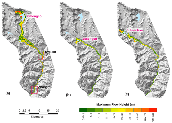
by delichon - >simulated worst-case outburst events from these lakes both in the Tibetan town of Nyalam and downstream at the border with Nepal
For context that's not where the flood happened, there's a massive mountain range in between those vallies reaching over 8000m (Shishapangma).
In earth science there are thousands of worst case scenario models published, but it's hard to actually predict reality.
- Clearly the point of this paper was not to flag a specific lake as being a specific problem. It seems pretty clear it's a case study meant to provide generalizable information and principals for remediation, and while they didn't predict the exact glacial lake that would collapse first, they were flagging danger in exactly the right region.by ip26
- Its easy though to bury sensors and sound sirens.by 21asdffdsa12
- It's just the opposite side of the same mountain, used as a case study for modeling GLOF risk. In fact, they prominently cite "Potentially dangerous glacial lakes across the Tibetan Plateau" [1], which includes Gyirong Port and the downstream valley as a high risk of GLOFs and notes that many buildings there are exposed to potential flash flooding. Take a look at Fig. 5 [2] - the upper left cluster of dangerous lakes and exposed buildings is the site of the disaster. They also name Jilong, Nyalam, Dingri and Kangding as the Tibetan counties with the highest lake danger; the glacier collapse happened at the border of Jilong county.
[1] referenced as Allen et al. (2019), https://doi.org/10.1016/j.scib.2019.03.011
[2] https://ars.els-cdn.com/content/image/1-s2.0-S20959273193015...
by yccs27 - The debris flow that has just happened doesn’t appear to be a glacial outburst.
Rather, the entire front face of a glacier at high elevation sheared off, likely millions of tonnes of material at least, crashed down a steep runnel, slammed into the opposing slope on the other side of the valley at the bottom, made that partially collapse, dammed the river for several minutes, and then all descended at high speed as the dam failed, with the results we see.
Some reportage is still saying there was an earthquake - there wasn’t - the landslide itself was the source of the seismic waves.
https://earthquake.usgs.gov/earthquakes/eventpage/us7000tbwb...
by madaxe_again - Brilliant analysis! Although china is notoriously bad at reporting earthquake data, I assumed in this case they were open and honest. It made sense that an earthquake would trigger this event. I do not fault anyone for interpreting the data this way. The USGS has been the agency I most trust in the federal government.
USGS is a fact finding organization. They do not regulate. They have been around since 1879. The land surveys they have done made huge impact on society. The reliability of surveys that they have facilitated has made an impact on industrial civilization that few will understand or ever hear about.
by ghastmaster - I can understand that this is not the exact location where the floods actually happened. But I am sad and I am frustrated and I am angry.
We had floods in Sikkim, which is practically a "stone throw" away from a world-level map point of view. I was there then. There was past research but everyone was so surprised. Activists talking about that event 10 years prior. Published reports.
Yet, we do nothing to move people away. To pause and think what the hell is going wrong. Just keep hustling and pretend shit is not going to go wrong. I am tired of our* culture.
our: all of us, I am not only talking about India, Nepal or China here.
by brainless