Join the discussion

Write your take first — we'll ask for email only when you're ready to publish.

  • Hacker News
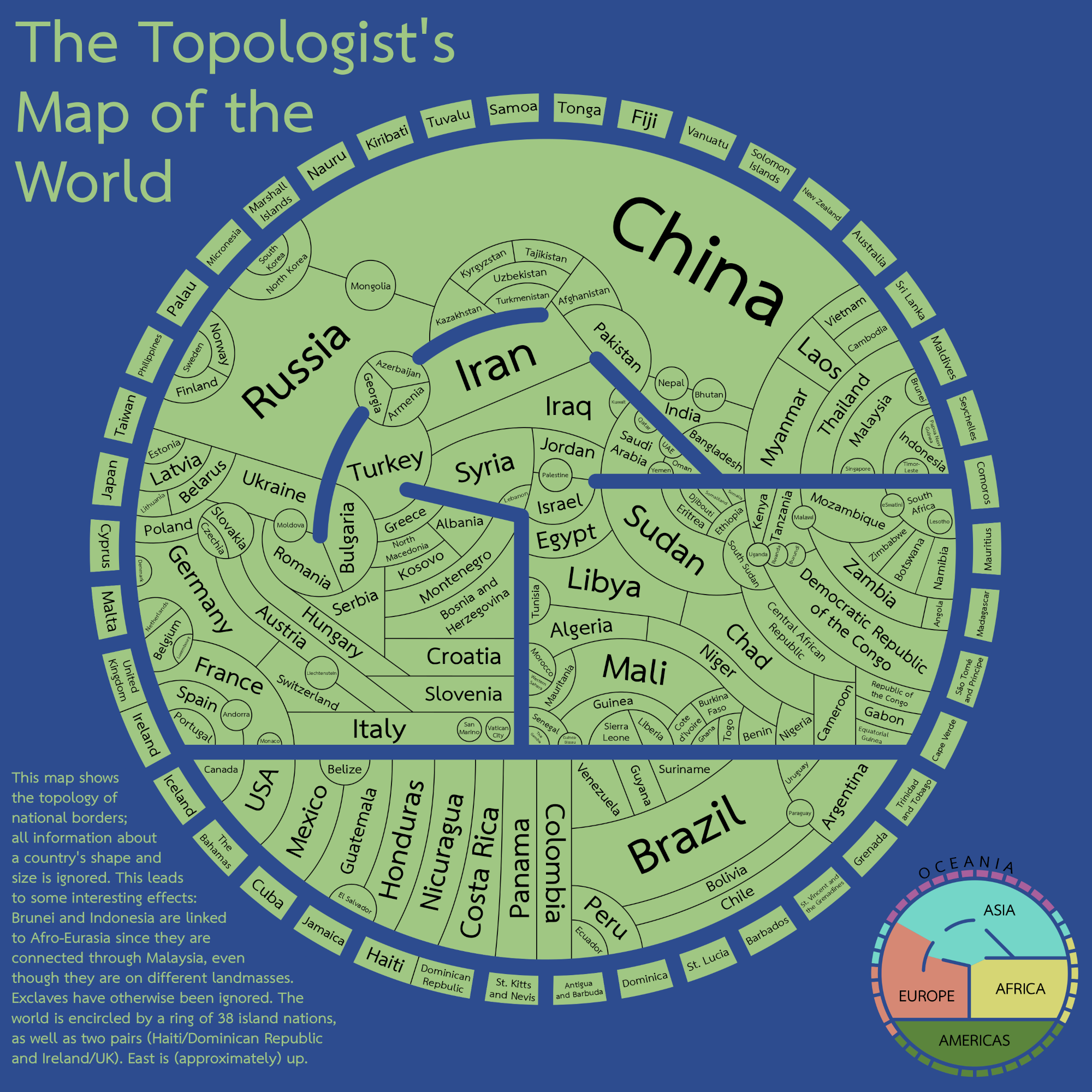
  • Seems incomplete? Like several island nations are missing (e.g. Bahrain).
    by Rury
  • This is super cool. I'd love to see it in a vintage style like that of old T-O maps!
  • Reminds me of some custom Diplomacy maps
  • I really like this and may have to try to make a poster.
  • Notably Oman, and Iran border seperate bodies of water.

    That would make things a lot simpler.

    [Edit, I stand corrected, there's a little bit that goes up to Iran and nips off a corner)]

    by Lerc
  • Thanks for helping me discover subreddit mapporn :) https://www.reddit.com/r/MapPorn/s/1IhrEkVXn7
  • Curiously, Eswatini (formerly Swaziland) is capitalized eSwatini, as if it is an e-commerce site.
    by kens
  • In siSwati it is known as eSwatini
  • The Netherlands and France share a border on the island of Saint Martin
  • France also borders Suriname and Brazil at French Guiana, Spain borders the UK at Gibraltar (and Morocco at Ceuta and Melilla)… there’s lots of pub-quiz-winning ones sprinkled about!
  • I was wondering a few days ago, if for teaching geography, one might collect compelling images/stories, which combined, might weave a familiarity with the layout of the planet?

    Commonplace, is Earth having a water hemisphere, and landed one. Or the now-distant but coupled shapes of South America and Africa. The rumpled bedsheets of the Indian plate collision. Then there's a green crescent of green China, SE Asia, and India, curved around a contrasting desert China and the Stans. Maybe China/Mongolia as a wedge inserted between Russian and SE Asia plus India, poking the Stans, injecting Silk Roads towards the Seas. The Blue Banana of Europe. Ring of Fire. Great Plains topographic funneling and tornados. Africa now desert and green, was khaki/green and less green, and Last Glacial Maximum was desert and dry.

    TFA map is another.

    Thoughts?

  • If you like this, you may like "Guess the countries just from what borders what" https://wilf.live/worldgraph/ (HN submission by the author wolfred: https://news.ycombinator.com/item?id=44604511 sadly without too much traction 3 points | July 2025 | 2 comments)

    [spoiler alert] Try finding Canada

  • Canada was my first guess, and I was able to get the rest of the Western hemisphere after that. I'm looking now for Portugal which i think should be pretty obvious, but I must be missing something.

    Edit. Also, I was wondering why there was no French Guyana, but being part of France means it's not a separate country. However, in that case France should share a border with Brazil. I wonder what other such quirks are in this map.

  • Since the creation of that map Canada and Denmark have gained a border (Hans Island). That barely registers on any traditional map but would dramatically rearrange this.

    EDIT: Or maybe it wouldn’t? I don’t see Russia’s border with Lithuania and Poland reflected (due to Kaliningrad) so maybe only the “main” part of a country is considered?

  • The map also disregards the Dutch/French border on Sint Maarten/Saint Martin, or the UK/Spain one at Gibraltar. In fact, I can't find the Dutch Caribbean anywhere. So I guess a lot of those small islands and borders were just ignored.
  • There's some simplification. I was initially puzzled about why it was United Kingdom and not Great Britain, as part of UK is on the island of Ireland. Also absent are countries that aren't fully independent, the largest being Greenland. Singapore is plain wrong. It doesn't share a land border with Malaysia.
  • Looking at the author’s Reddit post apparently things like exclaves were intentionally omitted for simplicity’s sake.

    https://www.reddit.com/r/MapPorn/comments/gxwn5r/oc_the_topo...

    Still doesn’t explain some things, like, why is Singapore (an island) shown on the map as having a border with Malaysia? Other countries connected by bridge or causeway (Denmark and Sweden, Saudi Arabia and Bahrain) aren’t shown as sharing a border.

  • It is remarkable how much it resembles the medieval T&O maps, including putting Jerusalem and the Mediterranean at the center of the world. (Which is what Mediterranean means.) And the East at the top (where we get "orient" from).

    https://en.wikipedia.org/wiki/T_and_O_map

    I am sure they knew that and the allusion is deliberate.

  • The obvious link between the two maps is neither has much concept of landmass size.The Americas are unknown in the first and unsatisfying imbalanced in the later map (Belize & El Salvadore, something must be done!). With all that in mind, it seems possible it could be a coincidence driven by similar constraints on both maps.

    The only choice here seems to be whether the containing shape is a circle, a triangle or a square.

  • This is moderately popular misconception which seems to be prevalent in English-speaking sources. Latin "mediterraneus" means simply between-lands.

    And "orient" is not "top" as other commenter already noticed.

  • "Orient" does not have anything to do with the top of the map. It refers to the rising of the sun ("oriens" in Latin means "rising", from orior, and "occidens" means "setting" when referring to the sun). Fun fact, the Greek word for orior is ἀνατέλλω and is where we ultimately get the word "Anatolia" from, since for the Greeks that's where the sun rises.